 Booking
Where to go
Where to go
Arnoltice is 9 km from Decin and 6 km from Hřensko, i.e. the border with Germany. The best way to reach us is by car. You can also get to Arnoltice by bus no. 432 from Děčín (direction Labská Stráň), which leaves every 1-2 hours. The journey takes about 25 minutes. In the main tourist season, the tourist bus no. 435 stops in Arnoltice, it’s a bus line from Česká Kamenice to Schmilka, Germany and back. It takes about 15 minutes to get to Hřensko on this bus. And of course, you can get to us on bikes (it’s quite up the hill) or you can take a beautiful walk from Děčín along the rim of Elbe Canyon (approx.15 km).
Arnoltice is located in the heart of Czech Switzerland and Elbe Sandstones. Moreover, this area is connected with Saxonian Switzerland, Bohemian Middlemountains and Lužické Mountains. That’s why it is an ideal starting point for countless walking or cycling trips. Here we present several trips, which you shouldn’t miss:


Through Suchá Kamenice to Belveder Viewpoint
It is a beautiful hike through the gorge of Suchá Kamenice, far away from the crowds of tourists. Leave Arnoltice on the blue marked trail in direction of Labská Stráň, after about 15 minutes you’ll reach the bottom of the gorge, which is surrounded by steep sandstone walls. The blue trail ends in the middle of the gorge, from here continue on the red marked trail to Labská Stráň and from there to Belveder, a sandstone terrace on the rim of Elbe Canyon, approx. 200 m above the Elbe River. There’s a restaurant at Belveder, where you can have some refreshment. From here you can get down to the river on the green marked trail or on the stairs starting directly from Belveder and later continue on the green trail again, which will take you to the end of Suchá Kamenice by the Elbe River. At this place, next to the bridge, you can see a “red spring”, which is a must-see. Continue through Suchá Kamenice on the red trail up the hill back to Arnoltice. On the way, notice the old time signs and messages carved into the sandstone. The whole hike is about 10 km long. With small children you can take bus from Labská Stráň back to Arnoltice.
Hřensko - Kamenice River Gorge (Soutěsky) and Pravčická brána
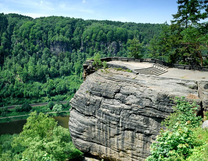
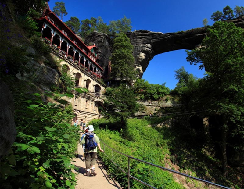
Pravčická brána (sandstone arch), Edmund Gorge (Edmundova soutěska) and Wild Gorge (Divoká soutěska) are apparently the most visited places in Czech Switzerland and indeed, visiting these places is really worth it. Go to Hřensko by car and park at the official parking by the entrance to the Gorge (about 5 km from Arnoltice). In the tourist season there’s a bus no. 435 from Arnoltice to Hřensko (15 minutes). Follow the yellow marked trail until you reach the dam of Edmund Gorge, from here you can continue only on the boat, when your boat ride finishes, continue walking to Wild Gorge, between the Gorges there’s a fast food restaurant, after the boat ride through Wild Gorge, walk up to Mezní Louka, here we can highly recommend Restaurant U Fořta. From Mezní Louka walk on the pleasant red marked trail to Pravčická brána, on your left side you’ll have open view of Czech Switzerland, on your side you’ll be walking along steep sandstone wall whose top makes the border between Czechia and Germany. At Pravčická brána you can have something to drink or eat at Sokolí hnízdo (Falcon’s Nest), don’t forget to climb the opposite viewpoint to take pictures of the arch with the surrounding landscape. After that walk down to Hřensko. The whole hike is about 15 km long.
From Růžová to Dolský mlýn (mill) and back
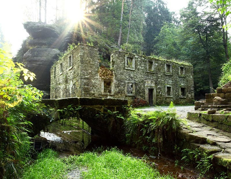
Walk or go by car to the beautiful village of Růžová (2 km), from here walk on the educational trail from Růžová to Kamenická Stráň and then continue on the yellow trail to Dolský mlýn, a place on the Kamenice River, where some famous Czech fairy tales were shot. Between Kamenická Stráň and Dolský mlýn, don’t forget to stop at Kamenická vyhlídka (viewpoint). On the way back you either take the same trail or you can choose to continue on the second part of the educational trail, which vines at the foot of the former volcano Růžovský vrch, called also Růžák or Děčín Fujisan. If you’re fit enough, you can climb to the top of the volcano. Back in Růžová, we recommend visiting Soap manufacture Rubens, Restaurant U Kostela or Restaurant 21, local beautiful church or you can walk up to the top of Pastevný vrch, called by locals Hutberg, from where you’ll have incredible views of the German table mountains. The whole hike is about 15 km long. You can also reach Dolský mlýn more easily from Jetřichovice (about 4 km round trip).
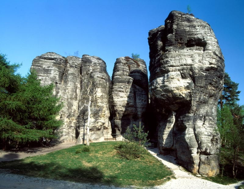
Jetřichovice and Mariina skála (Maria’s Rock)
Go by car to Jetřichovice (about 15 km), park your car in the centre of the village and follow the educational trail to Jetřichovické stěny (Jetřichovice Rock Walls). By using stairs carved into the sandstone and various ladders you’ll reach three of the most fantastic viewpoints of Czech Switzerland (Mariiana skála, Vilemínina stěna and Rudolfův kámen). When you return to Jetřichovice, you can climb up the ruins of the Falkenštejn Castle. The whole trip is about 4-5 km long.
Děčínský Sněžník and Tiské stěny (Tisá Walls Rock Town)
Děčínský Sněžník (in German – Schneeberg) is the highest mountain of Czech-Saxonian Switzerland (723m) and it is also the highest table mountain in Central Europe. It’s the place where the first TV signal in today’s Czechia was received. From the top of the mountain, you can admire magnificent views of Bohemian Middlemountains and Děčín to the south and east and Saxonian Switzerland with its table mountains to the north. You can even see Dresden. To reach Sněžník, walk from Děčín (7 km) or from the village of Sněžník (1.5 km). Tiské stěny is one of the Czech most beautiful rock towns, it is located about 4 km from Sněžník. It is also the filming site of The Chronicles of Narnia movie.
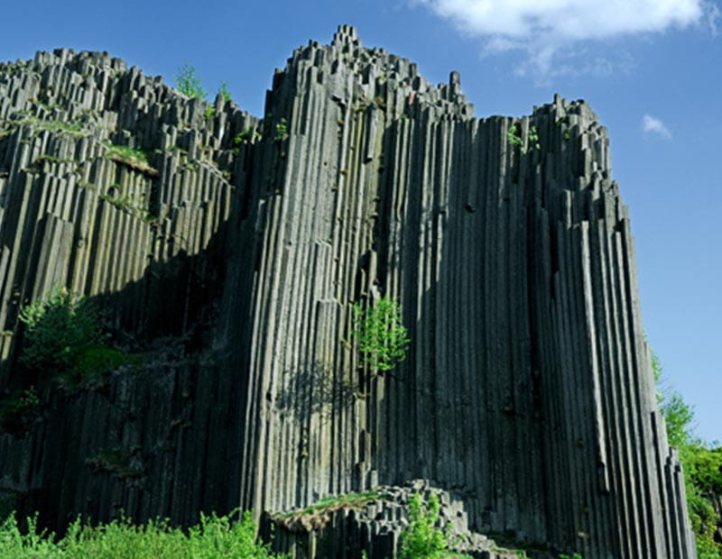
Panská skála
This national natural monument, so called rock organ, is located near the village of Prácheň by Kamenický Šenov. This geological formation consists of mostly vertically oriented basalt pillars in the shape of pentagons and hexagons. There used to be a basalt mine in the 19th and 20th century. After it had been closed, a small lake was created in the original mine. Panská skála has been protected as a natural geological formation since 1895 and it is considered to be the oldest geological protected area in Czechia. It’s easily accessible by car, bike or on foot.
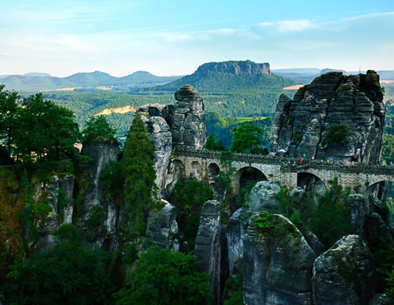
Kleine Bastei
Kleine Bastei is a viewpoint, which is less known than its bigger namesake (just Bastei) above the Saxonian village of Kurort Rathen. Despite this fact, it’s definitely worth visiting. To reach it, you have to take a steep climb marked with a green colour from the border village of Schmilka, about 7 km from Arnoltice. In summer it’s possible to arrive by the tourist bus no. 435 directly from Arnoltice. From Schmilka it is about 1 km walk. There’s a magnificent view of the Elbe Canyon and the table mountains of Zirkelstein and Kaiserkrone from the viewpoint.
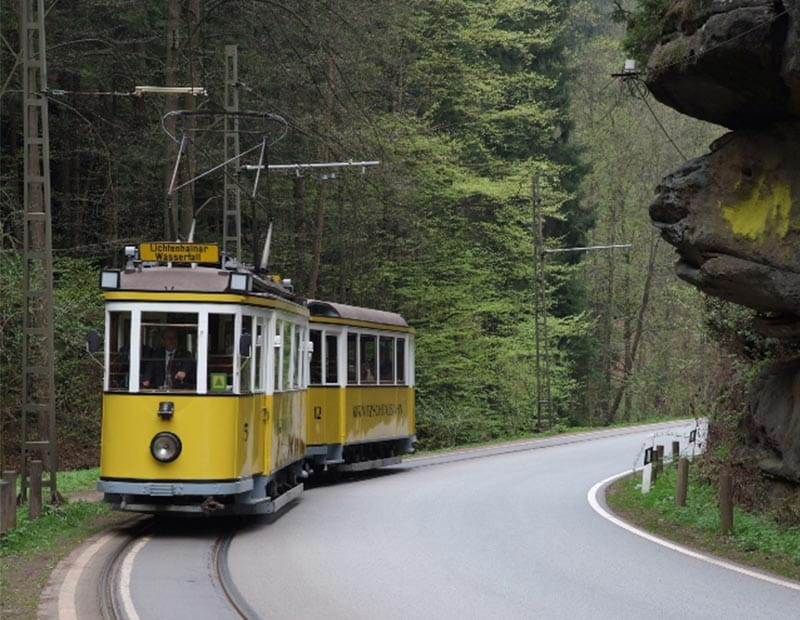
Bad Schandau, Schrammsteine, exterior lift, historical tram in the Krinitz River Valley
Bad Schandau is a picturesque spa town, located about 14 km by car from Arnoltice. Many tourists visit this place because of the Aquacentre Toskana Therme, but Bad Schandau is also the centre of the Saxonian Switzerland national park. If the weather is bad, we recommend visiting the visitor center of the national park, which has an interesting exposition in German, English and Czech. If the weather is better, Bad Schandau is a perfect starting point for the visit of Schrammsteine rock massif. You can also take a ride in the over 100 years old exterior lift to the rim of Elbe Canyon and watch two lynxes in a pen on top of it. From here you can walk to a beautiful village of Ostrau. One of the most interesting experiences is the ride on a historical tram in the Krinitz River Valley. The beginning of the tram line is in Bad Schandau, you’ll reach the final stop by Lichtenhainer Waterfall in about 30 minutes. After some time for admiring the waterfall, we recommend walking to a rock formation called Kuhstall and then come back and take a tram ride back to Bad Schandau.
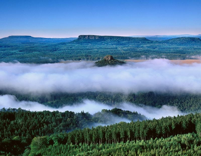
Table mountains in Saxonian Switzerland
Almost all table mountains of Czech-Saxonian Switzerland are located in Saxony, except the biggest one, that is Děčínský Sněžník. However smaller, all the remaining German table mountains offer a great hiking experience. Each of them deserves at least a half day trip. Their names are Königsstein (with a fortress), Lilienstein (a symbol of the NP), Papstein, Gohrissch, Pfaffenstein, Zschirnstein, Kaiserkrone or Zirkelstein.
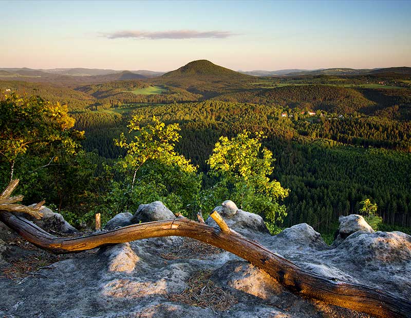
Růžovský vrch
Růžovský vrch peak or Růžák, also called the Děčín Fuji, is a striking basalt massif and national natural reserve 2.5 km south east of the town Růžová in the Děčín district. The body of the peak was formed by volcanic activity during the Tertiary period and constitutes a striking dominant feature in the landscape. Růžovský vrch peak is a striking basalt peak of conical shape in the cadastral territories of the towns of Růžová and Srbská Kamenice in the Děčín district. With its striking shape and its height in particular, rising in places to 300 m above the surrounding terrain, it constitutes an unmissable dominant feature in the landscape. At a height of 619 m above sea level, Růžák is the highest peak in the Czech Switzerland National Park, and it is the second highest peak after Děčínský Sněžník in the Czech-Saxony Switzerland area.